


esclangon reco 30 04 25

bymarc26
User
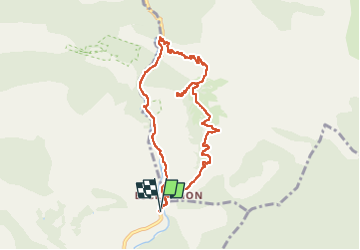

Length
9.2 km

Max alt
1124 m

Uphill gradient
395 m
Km-Effort
14.5 km

Min alt
750 m

Downhill gradient
395 m
Boucle
Yes
Creation date :
2025-04-30 10:19:52.72
Updated on :
2025-04-30 13:27:52.434
2h29
Difficulty : Medium

FREE GPS app for hiking
 SityTrail
IGN / Geographical institutes
SityTrail Plus
The world is yours!
About
Trail Walking of 9.2 km to be discovered at Provence-Alpes-Côte d'Azur, Alpes-de-Haute-Provence, La Robine-sur-Galabre. This trail is proposed by bymarc26.
Photos


Positioning
Country:
France
Region :
Provence-Alpes-Côte d'Azur
Department/Province :
Alpes-de-Haute-Provence
Municipality :
La Robine-sur-Galabre
Location:
Unknown
Start:(Dec)
Start:(UTM)
282305 ; 4897034 (32T) N.
Comments